OVER THE SKIES OF ALBUQUERQUE: BALLOONS GALORE!

With a nod from mother nature, on the last day of the Fiesta pilots were cleared to proceed.  By the dozens they floated into the dawn sky, a wonderous sight to behold! 


55918-ascend4.jpg

At the Fiesta, divisions disappear.  No borders, no religion, no politics.  Only balloon enthusiasts from all over the world gathering to share their passion and to defy gravity.  This being the 40th Annual International Balloon Fiesta, Albuquerque was ready with crowd control, transportation, lodging and other events to entertain  visitors from afar.


55920-glow8.jpg

Evening brings the balloon glow.  As the sun sets behind the Sandia Mountains and the Albuquerque sky dons shades of scarlet, the bands play and spectators arrive.  The pilots proudly light up their balloons.  Soon after the fireworks begin.


55919-glow3.jpg
 
55922-glow6.fireworks.jpg


55921-glow5.fireworks.jpg


THE STORM TROOPERS JOINED THE FESTIVITIES

55923-glow1.stormtroopers.jpg

We hooked up with our friends, Marlin & Peggy, who were camped in their RV at the Fiesta fairgrounds all week.  They travel with a group of “Lazy Dazers” and caravan all over the U.S., Canada and Mexico.  We met them for dinner at the Tomato Cafe, and parked near their RV for the Fiesta.

55962-Marlin.jpg


55924-ascend3.car.jpg


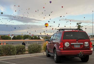
We viewed the farewell ascension from our car in a parking lot near the Highway.  Hundreds of colorful balloons filled the morning sky.  In Albuquerque there is what they call a box wind effect where balloons ride the wind currents n one direction, rise to a different air current level and ride back in the direction they came.


55925-ascend6.down.jpg


As the balloons land they have a myriad of obstacles to avoid:  buildings, power lines, fences, etc.  And then their retrieval crew must get to them.  Residents take this into stride as balloons land on their property.

55926-dawn5.jpg

.


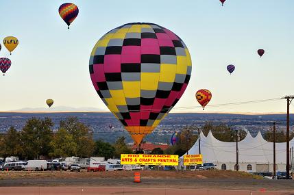
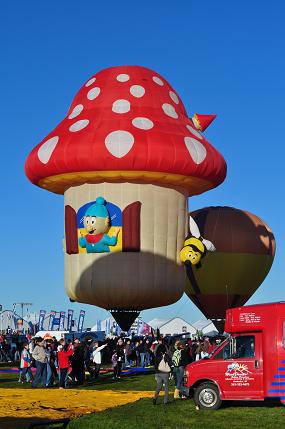
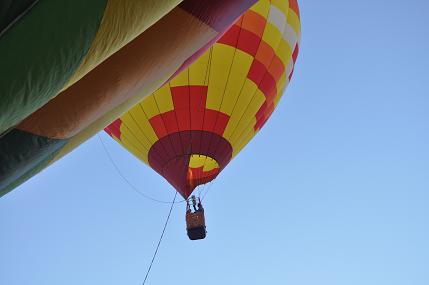
Balloons come in dozens of creative shapes.


55927-dawn9.butterfly.jpg

55928-dawn8.jpg


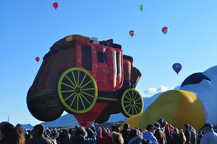
Many balloons are sponsored by companies for advertising purposes.


Here is the Wells Fargo Coach.


55929-dawn6.jpg

55930-dawn10.yellowjacket.jpg

55931-dawn11.jpg

How can Albuquerque host this successful event year after year?  “It is our  endless community spirit, excellent flying conditions, wide open spaces, festival atmosphere and undying camaraderies that bring pilots and fans back.”


WITH THE FIESTA OVER, THE FUN HAD JUST BEGUN.  WHAT A SURPRISE WAS AHEAD!


From Albuquerque we drove to Gallup and set up camp.  The camp host informed us that some of the balloonists were going to launch the next morning from Red Rock Park, only a few miles from Gallup.  We set our alarm and arrived at the park about 6:30 a.m.   There they were, getting their rigs together and looking for help.


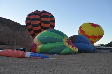
THE TARPS WERE SET OUT:


55932-Gallop5.tarp.jpg

55933-Gallop7.unfold.jpg


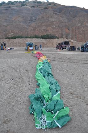
GROUND CREWS UNFURLED THE BALLOONS 


55941-add1.jpg


Alan helps unfold the balloon, almost getting pulled off the back of the truck.  Hard work!


55934-Gallop9.inflate.jpg

55942-add2.inflate.jpg


BLOWING AIR INTO THE BALLOONS WITH LARGE FANS, THEY START TO INFLATE. 


55935-Gallop10.up.jpg


AND THEN THEY BEGIN TO RISE! 

THE SUN IS FINALLY

WARMING THE

FIELD. 


55936-Gallop1.jpg

55937-Gallop2.Colin.jpg


WE WORKED ON THE GROUND CREW FOR COLIN GRAHAM’S BALLOON.  HE AND HIS WIFE LIVE IN YUMA.

AS THEY BEGAN TO RISE HE THREW HIS KEYS TO ALAN AND ASKED HIM TO TAKE HIS TRUCK AND RETRIEVE THEM WHEN THEY LAND.  THEY WERE OFF!


55938-Gallop3.Colin.wife.jpg

Imagine riding air currents above the red mesas of Indian country, silent, magic, uplifting..


55944-add3.shadow.jpg


55939-Gallop4.jpg

Racing through the backroads Alan finally spots Colin, his wife, and balloon floating in for a landing.

55947-add6.truck.jpg

They hit the ground softly. 

55945-add7.retrieve.jpg
 
55948-add8.packup.jpg

The balloon, basket, etc. are all packed into the truck.  Meanwhile, several other balloons land in the area and await their retrieval teams.


55949-add9.powland.jpg
55950-add4.land.jpg

As the drama comes to an end, we bid farewell to Colin and wife.  They head home to Yuma and we set off to Flagstaff by way of the Painted Desert and the Petrified Forest.


55940-Gallop15.Alan&.jpg

Looking out over the Painted Desert 

55951-Painted1.desert.jpg


55952-Painted3.desertInn.jpg


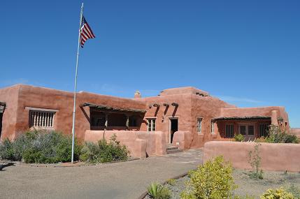
The Painted Desert Inn was constructed of petrified wood.  From 1947 to 1963 the hotel was run by Fred Harvey. It is now a National Historic Landmark.


55953-Painted4.desertinn.jpg


55954-Painted5.desertinn.jpg

The Petrified Forest:  Trees turned to stone.  They are a sight to see.  There are many stops on the road to view these ancient trees and walk among them.  There are two visitor centers and a museum with interpretive displays and movies.

55955-Petrified1.jpg
55956-Petrified2.jpg
55957-Petrified3.jpg

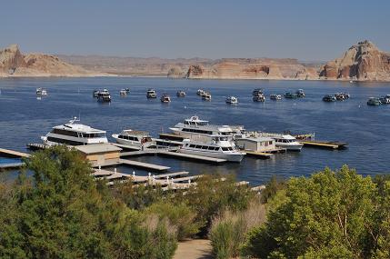
The road between the Painted Desert and the Petrified Forest crosses Route 66.  There are no campgrounds in the National Park but nearby is the town of Holbrook where you can stay in a teepee.  We also saw a nice RV park on the road to Meteor Crater.

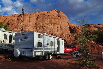
As this portion of our trip comes to an end, I’d like to share a favorite photo with you.  We passed this sight several years ago and since then had lamented many a time that we did not stop and take a photo.  It is located near Farmington.  Finally we got our picture!!

55958-JESUS1.SIGN1.jpg

We are off to Flagstaff and looking forward to dinner at a favorite restaurant:  Black Barts.  Here the wait staff entertains with opera and contemporary tunes.  It is located right in the campground across the highway from Little America. 

 And a word for a favorite vendor:  When we get to camp, Alan checks out the neighbors to be sure he has the tallest flagpole and the most lights.  We fly different flags and windsocks which make it easy to see camp when you are in a sea of RVs.  Helps the grandkids too if they are along.  My favorite is the kokopelli windsock *below.”  The company is called polesandholders.com.  You can order your pole on line!

55974-polesandholders.jpg 


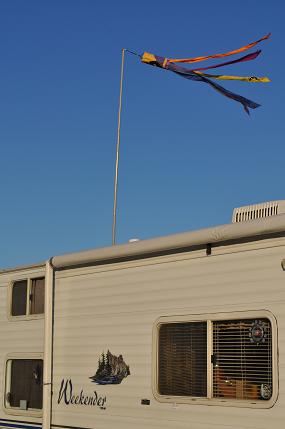
It’s a guy thing.  The camper with the tallest pole wins. 

MESA VERDE; CANYON OF THE ANCIENTS; GALLOPING GOOSE

Mesa Verde National Park in Colorado serves as a spectacular reminder of the ancient culture of the Ancestral Puebloans who lived there 1400 years ago.  The closest town is Cortez where we camped at the KOA.  It is a very visitor friendly park with accommodations for the handicapped, and options for those who are unable to climb the steep terrain or negotiate ladders to the cliff dwellings.  One of the most famous ruins in the park is Cliff Palace.  To enter you must take a ranger guided tour, climb ladders and stairs, trek steep trails, all at over 7,000 feet.  Or, you can take photos from the viewpoint:

55868-Mesa3.CliffPalace.jpg

Cliff Palace has over 150 rooms and was built from the late 1190s to late 1270s.  It has been restored to a point.


55869-Mesa8.cliff.old.jpg


This rendering on display at the visitor center shows what the Cliff Palace looked like when discovered by local cowboys in the 1880s.


55870-Mesa6.rendering.jpg


And an artist’s sketch of what life at Cliff Palace may have looked like when occupied.  The puebloans were farmers and spent much of their time getting food.  They were experienced builders.  Fortunately they tossed their trash close by and much of what we know about how they lived comes from those garbage heaps.


The Ancestral Puebloans are known to archeologists as Anasazi, from a Navajo word meaning “the ancient foreigners.”


For all their silence, these structures speak with a certain eloquence telling of people adept at building, artistic in their crafts and skillful at making a living from a difficult land.


We are fortunate for the opportunity to visit this historical sacred land.

55871-Mesa7.spruce.jpg

THE SPRUCE TREE HOUSE has changed very little in 700-800 years.  It can be viewed from a shaded viewpoint or accessed without a guide by a steep hike into the canyon and up the other side.  A spring is located nearby, making this dwelling a good place to live.

55883-Mesa10.kiva1.jpg


The Spruce House contains 8 kivas.  Alan insists the kivas are early ECV sites.


55885-Mesa10.kiva.alan.jpg 

He descends into the kiva to check it out. 


55886-Mesa12.kiva.jpg

The Museum located near these dwellings exhibits numerous displays showing the typical pottery and basketry crafted  by the Puebloans.


55872-Mesa9.museum.jpg

Headed down the Mesa Verde, we look out over the Valley toward Cortez

55873-Mesa2.view.jpg

 And back to camp after an exciting day:

55874-Mesa1.camp.jpg

DOLORES COLORADO HOLDS SOME PLEASANT SURPRISES

Located on the Rio de Nuestra Senora de las Dolores, or The River of Our Lady of Sorrows, Dolores claims to be a proud small town USA. It is home to the historic Galloping Goose Train Engine:  This hybrid vehicle, half bus, half rail car, ran the mail and passenger runs.


55875-Dolores2.GG.jpg

 The Galloping Goose (above) rode on the rails and at certain times of the year it rides again taking passengers for an historic experience.  Below is a photo of what the Goose looked like when in action.

55876-Dolores3.trainrender.jpg

THE ANASAZI HERITAGE CENTER

55877-Museum1.front.jpg

55878-museum3.sign.jpg

This beautiful museum interprets the history and culture of Canons of the Ancients National Monument and the Four Corners Region.  The special exhibit entitled Sacred Images of Native America Rock Art.  The photos are fascinating:

55879-museum4.koko.jpg

49626-museum6.jpg


49627-museum7.jpg

“The highest truths, which would not be communicable or transmissible by any other means, can be communicated up to a certain point when they are, so to speak, incorporated in symbols, which will hide them for many,no doubt, but which will manifest them in all their splendor to the eyes of those who can see.” – Rene Guenon

MONUMENT VALLEY, MYSTERY VALLEY, MEXICAN HAT AND A SWINGING GRILL; HOVENWEAP


     This sacred valley, north of the Arizona-Utah border, is a Navajo Tribal Park preserving the awesome geologic formations and offering insight into the Navajo way of life.  Just outside the reservation is Goulding’s Trading Post where there is lodging and a campground for RVs and tents. 

55825-MV.camp.Gouldings.jpg


The campground has a great view, its own pool, gift shop and laundry.  Nearby the motel has balconies with spectacular views, a restaurant and movie theater.

This complex is named Gouldings.

Gouldings was historically where stars were housed and hung out when movies were filmed in the area. It was a favorite haunt for John Ford who made many films, and John Wayne, who acted in them.  There is a movie museum on site, a collection of the area’s film history and personalities.

A few miles away is the Navajo Reservation.  After paying a fee of $5 per person, you may take the 17 mile drive on your own, or join a Navajo led tour which will allow you to see areas not open to those traveling on their own.  At the jumping off point is a new hotel called The View, trading post and restaurant.  We drove the area on our own, and also took a tour into Mystery Valley

SELF GUIDED TOUR:

55826-MV1.mitten.jpg

55827-MV2.mittens.jpg

55828-MV4.feathers.jpg
55829-MV5.vendors.jpg

An opportunity to buy handmade Navajo items from the crafters themselves.


55830-MV6.3sisters.jpg


The Three Sisters


55831-MV7.tree.jpg

 Sunset is a good time to photograph Monument Valley:

55832-MV8.sunrisejaps.jpg

GU55833-MV9.sunset.jpg

 GUIDED TOUR

On the reservation is Mystery Valley, known as Land of Long Shadows. Here you must join a tour led by a Navajo guide.  Our open-air, 4 wheel drive truck got us through areas of rough terrain.   Our guide, Don, was born and raised on this reservation and knew of all the secret spots.


55834-mystery4.truck.jpg


55835-Mystery1.goats.jpg


55837-mystery3.keyhole.jpg


55838-mystery5.finger.jpg

THE

FINGER      


55839-mystery7.cliffdwell.jpg

55840-mystery8.picto.jpg

Above are a cliff dwelling and a sample of the area’s petroglyphs

55841-mystery9.hands.jpg

The pictograph above is called “hands.”  Below, while we were photographing the cliff dwelling and cave art, our guide, Don, grilled burgers for our lunch


55842-mystery11.lunch.jpg


55843-mystery13.lunch.jpg

Our fellow tourists were from all over the U.S. and one couple was from Germany. 

55844-mystery14.hole.jpg


55845-mystery15.hogan.dead.jpg


A

SUMMER

HOGAN 


55846-mystery16.Lucee.jpg


WE WERE INVITED INTO LUCEE’S HOGAN AND SHE SHOWED US HOW SHE MAKES WOOL YARN AND WEAVES BLANKETS.


Below Lucee demonstrated how Navajo women tied their hair in the back with the wool yarn.

55847-mystery18.hair.jpg
55848-mystery19.hair.jpg

 We were indebted to our guide for sharing his Navajo culture with us.

55849-mystery17.donbest.jpg

ABOUT 25 MILES FROM MONUMENT VALLEY IS MEXICAN HAT.  THE PHOTO BELOW SHOWS WHY:


55851-Hat2.jpg

As the sun set over the hat, we visited a steak restaurant which had been on our list of “must sees” for years.  It is in the category of a few of our favorite out-of-the-way, unique places to experience.  Two of our favorites are Pappy & Harriets in Pioneertown near Yucca Valley, and Nellie’s Desert Bar near Parker, AZ.

THE SWINGING STEAK

55852-steak1.jpg
 

55853-steak2.jpg

THE RIB EYE WAS 18 OZ.  WE OPTED TO SPLIT IT.

55854-steak4.sign.jpg

OWNERS OF THE MEXICAN HAT LODGE AND THE SWINGING STEAK, VONNIE AND HER SON JAY DEE MUELLER, WERE ON HAND TO CHAT. 

55855-steak3.jpg

We are fortunate that in this Country we have set aside these cultural, historical and geological unique lands for future generations to enjoy.  The national parks and monuments are here for everyone to experience.  How many residents of the American west enjoy these parks?  We found that many of the visitors we encountered had negotiated through the tribulations of air travel, car rental, etc. to visit these parks.  And yet, Americans who pay for the parks and live within driving distance often overlook the beauty and significance of what lies in their backyard.  Remember, if you are over 62, purchase a Golden Age Pass and you can enter these parks and monuments free of charge.

DON’T MISS HOVENWEAP

Located in the Four Corners Area of Utah, this National Monument is on a Navajo Reservation.  There is a visitor center and several hikes along the rim where structures are easily photographed.  Round, square and D-shaped towers mark once-thriving communities abandoned 700 years ago.  Why were these towers built?  It has been suggested that the ancestral Pueblo people were protecting something.  The area stimulates the imagination. 

55862-Hoven1.jpg

55863-Hoven2.jpg

55864-Hoven3.jpg

55865-Hoven4.jpg

55866-Hoven5.jpg

55867-Hoven6.jpg

ANTELOPE SLOT CANYON, A NATURALWONDER AND HORSESHOE BEND


In Indian Country there are a number of slot canyons.   In the city of Page, AZ near Lake Powell, we signed up for a tour of Antelope Slot Canyon.  Access is allowed only with a Navajo Guide.  Loaded into a truck we headed for the Navajo Indian Reservation for an incredible experience. 

55699-slot13.truck.jpg

Carved by elements of sand, wind and water for billions of years, the walls tower over 200 feet and in areas you can touch both sides with your elbows at the same time.  The brilliant contrast of penetrating sunlight and sandstone colors leaves nothing to be said.  Just take a look at the photos and you will see why there are no words….

55700-slot1.jpg
55701-slot2.jpg
55702-slot3.jpg
55703-slot4.jpg


55704-slot5.people.jpg

Several tours were walking thru the slot cave and many languages were spoken.  Fortunately the photos were shot up to the opening, so the crowds were not in the way.


55705-slot6.jpg

55706-slot7.jpg

55707-slot8.jpg
55708-slot9.michael.jpg

55709-slot11.outside.jpg


After emerging from the end of the slot, we gathered and then walked back in for the trek to exit where we had entered.  This is not a place you want to be when rain might spawn a flash flood.


55710-slot10.lizard.jpg


The official slot canyon greeter.


55711-slot12.linda.michael.jpg

After the slot canyon tour, we said goodbye to our new friends, Michael and Linda.  We had met them on our Lake Powell boat excursion and were happy to see them again on the slot canyon tour.  They too were exploring all the wonderful sites in Indian Country.


After the incredible scenes in that cave, we were off to another local natural site:  Horseshoe

Bend.  Here, below Glen Canyon Dam and before Lee’s Ferry, this bend in the Colorado River is a strange sight! 

55712-horse1.jpg

55714-horse3.jpg
55713-horse2.jpg

With Lake Powell and Rainbow Bridge, Antelope Slot Canyon and Horseshoe Bend behind us, we head for Monument Valley

INVITING LAKE POWELL (GLEN CANYON NATIONAL RECREATION AREA)

Words of advice:  Don’t even try to figure out if you are in Arizona or Utah, leave alone what the real time is.  Just enjoy!

55620-lake1.view.jpg

Leaving the magnificent geologic beauty of Zion, Cedar Breaks and Bryce, we arrived at Glen Canyon National Recreation Area, an area we call “Lake Powell.”  Here a new dominant color made its debut:  blue!  All around us arches, buttes, mesas and a wide variety of shapes and forms are anchored in water.

The Campground at Wahweap Marina is beautiful, each site privileged with a great view. 

50907-camp11.jpg

The lake, of course, was not in nature’s grand plan, but the result of the flooding of the valley after the construction of Glen Canyon Dam which was completed in 1966.  There was a fair amount of controversy with conservation of water, the production of power and control of the river pitted against the destruction of Native American sites and geologic wonders which now lie at the bottom of the Lake.


 Whether you rent a houseboat or small boat on your own, or book a tour on a commercial boat, getting out on the lake is the point!   We chose a 5 hour boat excursion to Rainbow Bridge.


55621-boat1.jpg
55622-lake2.view.jpg

The lake level is low, but higher than it was a few years ago when it was at such a low level the closure of the power plant was being considered.  Because the lake is not at its highest, our boat tied up about a quarter mile from Rainbow Bridge and we walked to the bridge.  


55623-lake4.bridge.jpg

The short jaunt was well worth it.


55624-lake5.bridge.jpg

They say Rainbow Bridge is sacred to at least five different American Indian tribes so we had to refrain from hiking too close or climbing on it.


55625-lake6.bridge.jpg
55626-lake7.bridge.jpg

Boating home, we patted ourselves on the back for choosing this adventure!


55627-lake3.viiew.jpg

Of course, renting a houseboat for a week would be a better way.  We put that on our agenda!


55628-lake9.marina.jpg 


The Wahweap

Marina


Campground guests are invited to use the hotel pool.  There we kept one eye on the lake, one eye on the cocktails and appetizers, and turned a blind eye to the male German tourists wearing speedos.  Alan refused to take their photo.


55629-pool1.jpg

Anxious to get back out on the lake in a different light, we enjoyed a dinner cruise.  It was a lovely boat, the food was great (fresh trout!) and the scenery spectacular!

55630-dinner1.jpg

55631-dinner3.jpg

To learn about how and why this lake was formed, we made a stop at the Carl Hayden Visitor Center at the dam.  There you can view the dam and bridge.

55634-dam5.sign.jpg


55633-dam2.jpg

Concrete for the arch bridge and power plant was poured around the clock for three years.

55635-dam3.jpg

55661-dam7.bridge.jpg
The lake is named for John Wesley Powell who, with his party, mapped the area and recorded its natural history in 1869.  There was, of course, no lake at that time and these brave men floated the rapids of the Colorado River.  What would Powell think if he saw the area today?

There are two sites nearby that are a must for visitors:  The Antelope Valley slot canyon and Horseshoe Bend.  They are so picturesque they deserve their own chapter in this blog!.

Posted in Uncategorized | 1 Reply

ZION, LAND OF SANCTUARY, TO BRYCE, LAND OF HOODOOS

The most obvious stopover when headed to Zion National Park is Las Vegas.  The glitz, lights and sound of coins dropping give great contrast to the sanctuary of the cathedral of sheer cliffs and tumbling rivers which lie beyond. 


55543-zion1.jpg

The Zion River Resort, RV Park & Campground is located 13 miles from the entrance into Zion.  Campsites are surrounded by a lively creek and the tumbling Virgin River.  Sitting on the berm behind our site watching for birds, I spotted a bobcat lurking at the creek’s edge.  I fetched my camera and shot a photo.  When the cat heard the camera’s click, its ears perked and it tensed into defensive stance.  We stared at each other for a long time, then it backed into the reeds and disappeared.


55544-zion29.tram.jpg

Zion is best experienced early, before the sun penetrates the gorge floor.  Until October 30, visitors must travel by tram, but trams arrive in 7 minute intervals so it isn’t a problem and relieves the congestion inherent in a park that attracts visitors from all over the world.  Almost each of the 8 or so tram stops offer a special walk or hike or attraction, a museum, lodge, restaurants and visitor center.


55545-zion6.view.jpg
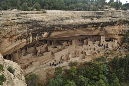
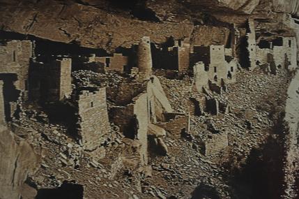
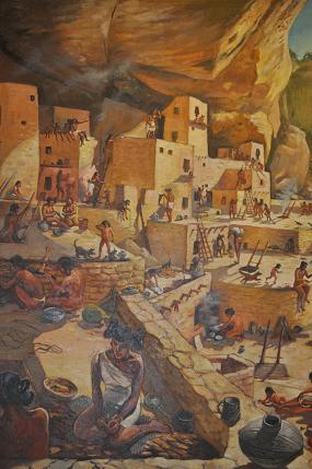
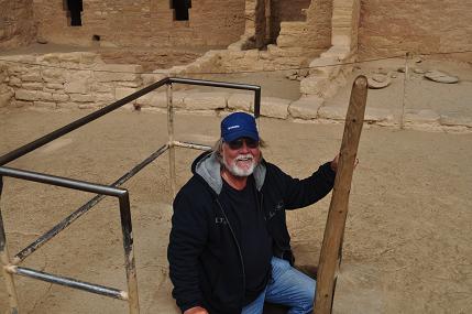
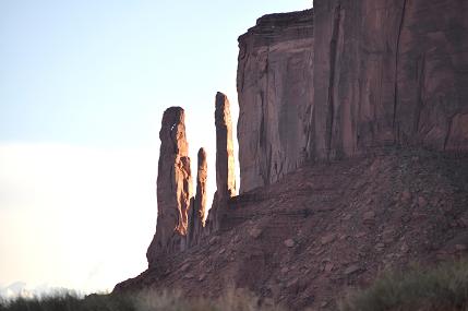
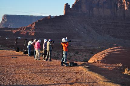
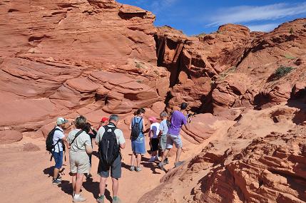
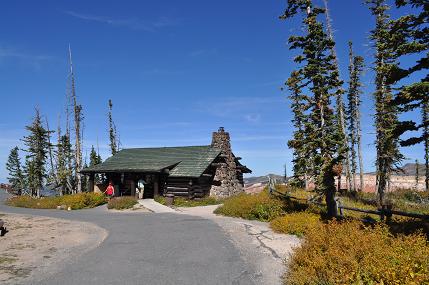
Everywhere the view is awesome. We were surrounded by hundreds of foreigners and seniors geared up in the latest hiking attire, topped with hats, footed with boots, and strapped with a variety of contraptions to hold water bottles, sun block and cameras.  Oh, and everyone had a walking stick, a map, and a sense of purpose. 


55546-zion13.view.jpg

The last tram stop is where you can hike a mile and a half to the “narrows.”  For the hearty, at that point, you continue on where the trail ends into the river.  An assortment of hiking sticks are propped against the cliff wall, each having been cast off by hikers before. 


55547-zion12.sticks.jpg

We were told that upstream a ways these brave hikers walk in the chilly water up to their shoulders.  It is also said that there are spots in the gorge where hikers can touch their elbows to the walls on both sides at once.  It is suggested you get the hell out fast if a flash flood occurs.


55548-zion7.view.jpg

Zion means “promised land,” and for centuries has served as a sanctuary to those who have entered.  It is a canyon where the dramatic meets the subtle, and the scenery is awesome whether you look up, down or to the side.  The sheer cliffs tower, the Virgin River tumbles swiftly by, the forming arches on cliff walls weep into clear pools and wildflowers blaze with color.  While gazing at the large, don’t forget the small.


55549-zion11.squirrel2.jpg
55550-zion8.squirrel.jpg
55551-zion9.weepingrock.jpg
55552-zion16.lodge.jpg


Zion Lodge 


Back at camp, we enjoyed meeting a couple from  Northridge – Dory and Lou.  We soaked in the pool and spa, sat round an evening campfire, and explored the night sky. Near camp there is a fort, prime for photos:

55554-zion2.fort.jpg
55555-zion3.fort.jpg

 BETWEEN ZION AND BRYCE, A PLEASANT SURPRISE!

CEDAR BREAKS NATIONAL MONUMENT

If you drive from Zion to Bryce without stopping at Cedar Breaks National Monument, you have missed something special!  This huge natural ampitheater has been eroded out of variegated Pink Cliffs.  The rim is over 10,000 feet above sea level.  Our first stop was the visitor center then a walk out to Supreme Point where a man was helping his 93 year old father to the view.  The old man talked about his trip to that very spot in the 1930s.

55562-CB3.lookout.jpg


55568-CB14.hoodoo.jpg
55564-CB7.view.jpg

Sad to leave the beauty of the canyon we headed to Bryce, only to find that the drive paralleled all of the beautiful sites we had beheld so far.  We were excited to see a brilliant display of fall colors along the way.

55560-CB1.colors.jpg
55565-CB9.color.jpg
55566-CB12.color.jpg
55567-CB13.color.jpg

AND JUST WHEN WE THOUGHT WE HAD SEEN IT ALL, WE HAPPENED UPON THE UNIQUE MOQUI CAVE!

Expecting a silly cave with plastic gnomes and glitter, we were pleasantly surprised to find a truly historical spot.  Greeted by Lex Chamberlain, we became emersed in history, rocks, fossils, a pub, marbles, carvings, photos, and much more. 

55573-moquilex.jpg


55569-Moqui1.front.jpg

Lex talked about his father, a man of many talents, who has since passed.  He played professional football for the Pittsburg Steelers, was a sculptor, artist and rubbed elbows with movie stars who had bellied up to the cave pub while filming movies in the area.  One such actor was Ronald Reagan.  “Dad” created a sculpture of the star and on the wall is the thank you letter he received in return. 

55571-Moqui5.movies.jpg
55572-Moqui6.dad.sculptures.jpg


Photo of “Dad” posing with his sculptures


Some displays were whimsical:

55574-Moqui3.horns.jpg

“Dad’s” collection of dinosaur fossils found in the area was impressive:

55575-Moqui4.trax.jpg

As was his rock collection:

55576-Moqui8.rocks.lite.jpg

55577-Moqui9.register.jpg

The cave is located on Hwy. 89 5.5 miles north of Kanab, Southern Utah. After perusing the gift shop, we said goodbye to Lex and headed for Bryce.


BRYCE CANYON NATIONAL PARK, LAND OF HOODOOS

Bryce Canyon National Park was established in 1928 and named after Ebenezer Bryce, a cattleman who settled in the area in 1875.  Walking along the rim visitors look down at the 8,000 foot dropoff into a fairyland below.  If Zion is a land of drama and magnificence, Bryce is a canyon of intimacy, bathed in blissful hues of baby cheek pink, tangerine, coral and peach.

55559-Bryce2.view.jpg

At Zion it is somewhat daunting to look straight up sheer walls which seem to defy gravity, whereas at Bryce hikers cannot resist descending the canyon trails to become more closely acquainted with the hoodoos and spires.


55578-Bryce3.hikers.jpg

The canyon is so inviting that we trekked to Sunrise Point at 6 a.m. and there we were surrounded by visitors from all over the world poised on the rim, cameras clicking.

55579-Bryce5.sunrise.jpg


55580-Bryce7.photographers.jpg


55582-Bryce8.sunrise.jpg

55587-Bryce6.sunrise.jpg

Everywhere on this trip we have been surrounded by visitors from other countries.  In the campground they are in groups camping in El Monte RV Rental rigs.  Ruby’s Inn is the gathering place just out of Bryce.  Here there is the RV park, motels, restaurants and gift shops.  In the evening we had a “western” experience at Ebenezer’s.  Here a bbq dinner is followed by a western show.  We sat with two lovely young ladies visiting from Amsterdam.  They are both doctors, so of course Alan had to ask them what they thought of ObamaCare.  They said they were puzzled why anyone in the US would be against it.  They have universal healthcare in Amsterdam and it works well.  They said it is just a part of life. 

We also noted that at the dinner, they displayed flags representing countries where the dinner guests came from for that night’s show.  There were 14 flags for 14 countries, and Mexico wasn’t one of them! 

We said goodbye to Bryce and headed on to the next leg of our journey:  Lake Powell.